Enregistrez gratuitement cette image
en 800 pixels pour usage maquette
(click droit, Enregistrer l'image sous...)
|
|
Réf : V01795
Thème :
Terre vue de l'espace - Montagnes - Collines - Neige - Glace (539 images)
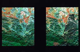
Titre : Changes in Santa Monica, CA Mountains
Description : (La description de cette image n'existe qu'en anglais)
These two images of the Santa Monica Mountains were taken by NASA's Airborne Visible and Infra-Red Imaging Spectrometer (AVIRIS). They show changes on the ground caused by the Calabasas/Malibu fire that started on October 21. The image on the left was taken on October 17, four days before the fire. The image on the right was taken on October 23. Scientists and fire agencies are using these images to map the chaparral vegetation in the region to help them understand the potential for future wild fires. The area of the image measures 10 kilometers by 11 kilometers (6.2 miles by 6.8 miles) and is centered near Agoura Hills. The line near the top of the image is the 101 Freeway. In the image on the right, the dark purple region is a portion of the fire scar. The road just to the left of the burn area is Las Virgenes Road. Malibu Lake is the black, arrow-shaped region. Mulholland Highway is the red line just north of Malibu Lake. The bottom part of the image is Malibu Creek State Park. The AVIRIS instrument flies aboard a NASA ER-2 airplane. Earth scientists use AVIRIS to conduct research and applications across a range of scientific disciplines, including ecology, geology, mineral hazards, snow and ice, coastal and inland waters, and wild fires. AVIRIS was developed and is managed by the Jet Propulsion Laboratory for NASA's Office of Mission to Planet Earth.
|
|

